|
 |
|
|

I discovered the world of maps while working at DeLorme Publishing in Yarmouth, Maine, in 1979-81. During my time there we published several Maine map & guides (Baxter, Moosehead, Allagash), fishing and field guides, and an all-new edition of the Maine Atlas & Gazetteer. To do my job as in-house editor and girl Friday, I had to gather information about interesting places and pinpoint their locations on maps and atlas pages. For someone with a flair for editing and an explorer’s curiosity about my home state, it was a perfect job. I learned a lot about researching and compiling, exploring, publishing, editing, and—by osmosis—mapmaking.
DeLorme was moving into digital mapping, and with my projects finished I saw my way pointing Downeast, beckoned by old friends and family roots—plus all those alluring places I had read about compiling the Gazetteer! I moved to the Blue Hill Peninsula and a part-time job at WoodenBoat magazine. To round out my income I did some freelance editing for Canoe magazine, along with drawing maps of canoe routes. I’d always been good at art and hand lettering, had learned about maps and graphic design, and in doing map illustrations for both magazines I figured out how to produce simple camera-ready map layouts.
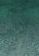
Then I got an idea: Why not make a map of the Blue Hill Peninsula, which had lots of special places—and countless ways to get turned around? My original intent was a poster-size map, but a friend at WoodenBoat suggested, “While you’re at it, print the map as a postcard too, large enough for giving directions.” Though I based the map’s lines on topos and nautical charts, I wanted it to be as accurate and detailed as only a “local” could make it, so I drove around field-checking scenic views and boat launches, asking local input. Then, the excitement of getting the map printed and into stores. People loved the map—and would I make maps of other Maine regions? Suddenly I was a mapmaker and publisher, as well as an editor.
Since 1983 and that first map, I’ve worked my way around Maine’s coastal and lake regions, making “map portraits” of special places—which, for me, by definition involve lots of water. My stippling and “watercolor” shading styles have evolved to highlight the beautiful intricacy of Maine’s coast and lakeshores, islands and peninsulas.
All drawn and “pasted up” by hand—borders, symbols, decorations, and calligraphy labels—the artwork, especially for my two-color posters, is labor-intensive, created using techniques of the previous generation of graphic arts. As a self-taught map artist, I prefer the hands-on craftsmanship and low-tech independence of making maps this way. However, with the digital revolution I’ve had to adopt scanning, typesetting, and graphics software (in collaboration with a designer) for updates and a few new maps.
Freelance editing (click here for my editorial resume) is still the other part of my work life, which I love equally along with writing, so I’m content with rounding out my series of hand-drawn maps as much of my time is devoted to editing. Art and boat books, gardening and homesteading, cookbooks, and memoirs are some the genres I enjoy working with—always something new to learn! My map-reading skills come in handy while copyediting hiking, paddling, camp-cruising, and ecological guides. Along with keeping my maps in print, I occasionally do simple custom map illustrations for authors, publishers, and conservation groups.
 Although I’ve made a couple of whimsical maps for fun (the parody charts), I take accuracy seriously. For all my maps, I’ve researched each region exhaustively, by reading, comparing other maps of the same place (you’d be amazed how they differ), field-checking (road rally with a friend), and enlisting knowledgeable locals as map proofers before going to press. Yet I try to keep things clean, simple, timeless—complete, without clutter.
An inevitable result of working with maps is a growing curiosity about place names and their origins, the geological and human history of a place, and the
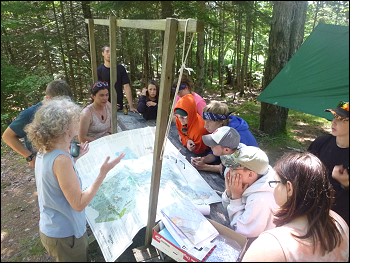
history of Maine mapmaking. Talking to school groups about mapmaking, I was looking for a way to make map presentations more fun and educational, and thought of a scavenger hunt. For me, gathering information to make a true and accurate “map portrait” is a kind of scavenger hunt, drawing on maps, guides, and other resources and putting it all together, and I wanted to convey that explorer’s curiosity—introduce explorers of all ages to the skill of map-reading and get them to flex their deductive-reasoning muscles. This developed into a unique adventure called “Map Sleuthing Downeast,” where teammates scrutinize topos, nautical charts, historic and other maps and guides, and put two and two together to learn about local place names, history, Native American canoe routes, watersheds, contour lines, navigation, and geology. More recently, I’ve been sharing these map-reading skills correlating map details with landscape photos in a sequence of slides, “Exploring Downeast Maine through Maps.”
Two of my favorite sources of downeast Maine history are Colby’s historic atlases of Hancock County and Washington County, originally published in 1881. If you’ve come across remnants of history in the landscape—old quarries, cellar holes, wharves, sawmill abutments, and impoundments—and wondered about their stories, the 1881 atlases hold many clues! Learning the original editions were long out of print, I decided to publish newly arranged editions of both atlases, each a detailed time capsule of life in the late 19th century. In each Coastwise Geographic Edition, Colby’s archival town, village, plantation, and timber/lot plans are grouped geographically, with a preface, period photos, bibliography, and index of old and current place names making these historic county atlases more user-friendly for today’s time-travelers and explorers. www.ellsworthamerican.com/living/nearly-140-years-later-new-colby-atlas-edition-produced
 It's all about inspiring a sense of place and appreciating our surroundings. When you see the real landscape in the map, and then take what you learned from the map to see much more in the landscape, you’re a true explorer, oriented in place.
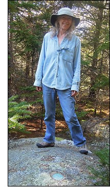
When not mapmaking and editing—or writing, cooking, playing with colors and fibers—you’ll find me hiking and paddling, snowshoeing and benchmark hunting, exploring the woods, streams, and ponds around Hancock County and the Downeast lakes.
Enjoy my maps, and happy exploring!

|
|
| Jane Crosen, Mapmaker, 110 McCaslin Road, Penobscot, ME 04476 © 2025 |
|
|